

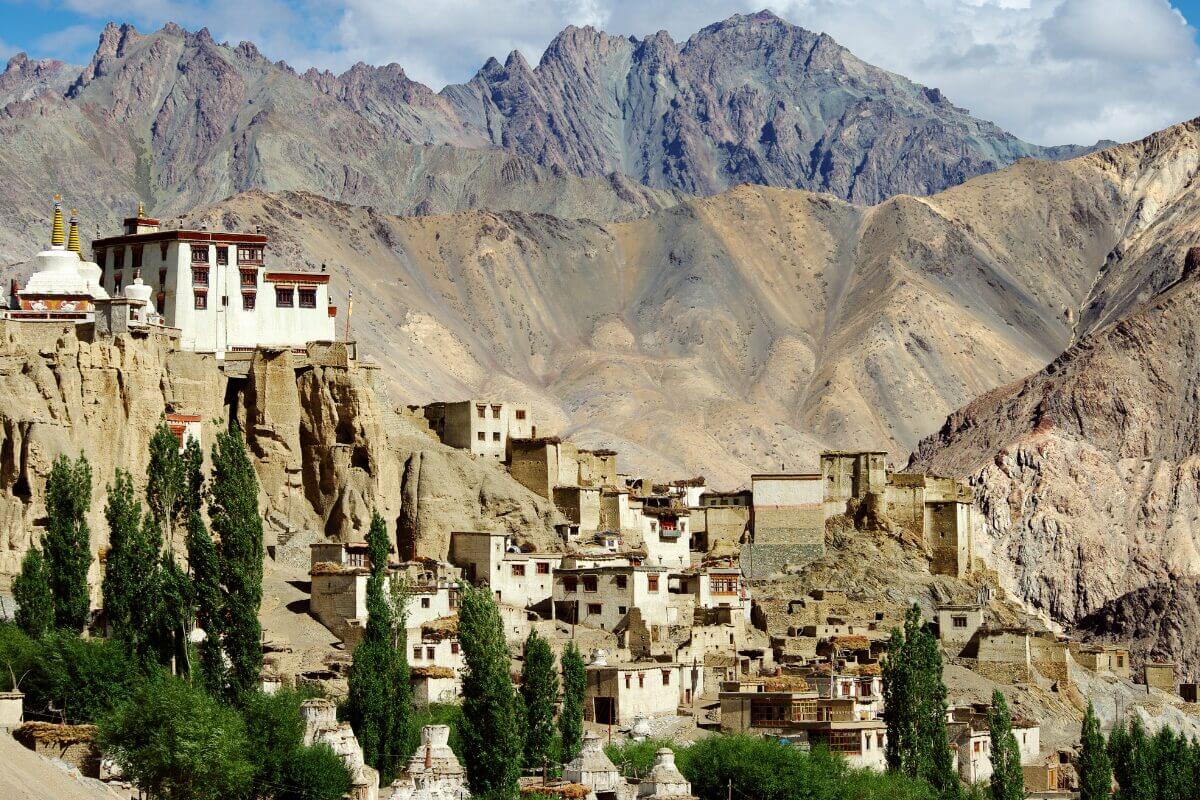
Lamayuru is a small village in western Ladakh, known for its ancient monastery and its unique moon like landscape. It is located at an altitude of 11,500 feet (3,505 meters). Lamayuru offers a peaceful stop for those interested in Buddhist heritage, meditation and geology. It is situated 125 km away from Leh on Srinagar Leh highway. Often called “Moonland” because of the strange, craggy formations in the surrounding hills, Lamayuru is one of the most photogenic and spiritually calming destinations in Ladakh.


Lamayuru Monastery – One of Ladakh’s Oldest
Lamayuru is home to the Lamayuru Monastery, also known as Yuru Gompa. It is believed to be one of the oldest monasteries in Ladakh, dating back to the 11th century.
The oldest surviving structure in Lamayuru, the Seng-ge-sgang temple, is attributed to the great builder-monk Rinchen Zangpo (958-1055 CE). Commissioned by the King of Ladakh to build 108 monasteries, Rinchen Zangpo’s work significantly shaped the early Buddhist landscape of the region.
“It is said that this valley was once a lake, and a Buddhist saint dried it up to build the monastery.”
Lamayuru is also known as “Tharpa Ling” which translates to “place of freedom.” This name originates from the 16th century when the King of Ladakh, Jamyang Namgyal, after being cured of leprosy by a lama, bestowed the monastery and its surrounding area with special privileges, including tax exemptions and declaring it a sanctuary where no one could be arrested.
Lamayuru hosts two significant annual masked dance festivals, known as “Cham,” in the second and fifth months of the Tibetan lunar calendar (usually March and July).
Why Lamayuru is also known as ‘Moonland’?
The hills around Lamayuru are made of soft, eroded clay and rock, which gives them an appearance like the surface of the moon. This unique terrain makes Lamayuru stand out from other places in Ladakh. And it’s favorite among photographers and geology lovers.
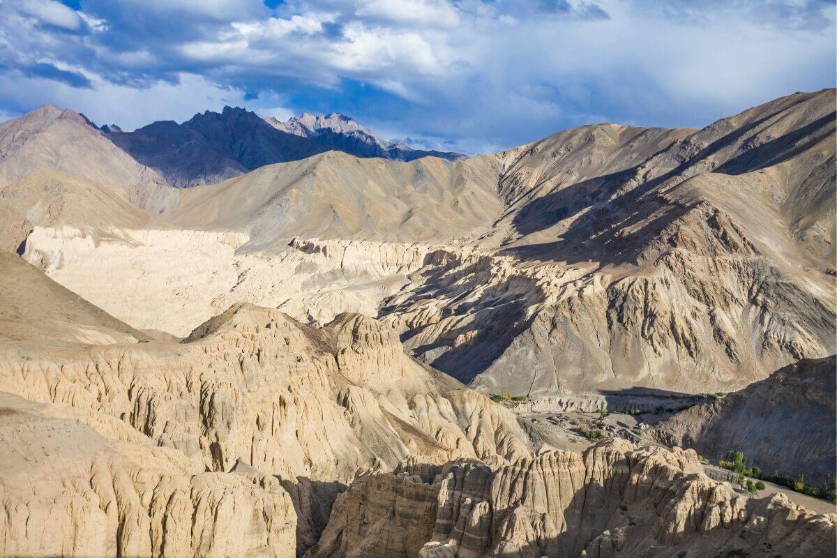
You can view the “Moonland” landscape from several roadside viewpoints, especially while driving toward Kargil or returning to Leh.
How is Moonland formed?
The “Moonland” is a geological wonder. The Lamayuru Formation itself consists of shales, schist and phyllites of Triassic-Jurassic age. The unique eroded landscape is attributed to a lake that existed around 35,000 years ago. Tectonic activity caused landslides that dammed the Lamayuru River, forming this lake. Over time, the lake receded and the sedimentary deposits were sculpted by erosion into the dramatic formations seen today.
Nearby Attractions
- Wanla Monastery – A lesser-known gem 14 km away, with beautiful paintings and a peaceful location.
- Fotu La Pass – At 13,478 ft, it’s one of the highest points on the Srinagar-Leh Highway, offering panoramic mountain views.
- Lingshed Monastery – For offbeat travelers or trekkers heading to Zanskar, this remote gompa is reachable via rugged trails or the Singge La route.
- Alchi Monastery – An hour’s drive toward Leh, Alchi is known for its Indo-Kashmiri style murals and is one of the oldest surviving monastic sites in the region.
Why it is worth to visit?
- ✅ Visit one of Ladakh’s oldest and most peaceful monasteries.
- ✅ Walk through a village surrounded by moon-like hills.
- ✅ Learn about Tibetan Buddhism and local legends.
- ✅ Great photography stop on the Leh – Kargil highway
- ✅ Experience local life in a less-touristy and quiet place.
Travel Info
- Altitude: ~11,500 ft / 3,505 m
- Distance from Leh: ~125 km (approx. 3.5–4 hours)
- Distance from Kargil: ~115 km
- Best Time to Visit: May to October.
- Permits Required: Not required for Indian citizens or foreigners.
- Stay Options: Guesthouses and homestays near the monastery and village.
- Mobile Network: Limited; BSNL works occasionally.
- Ideal For: Spiritual travelers, culture lovers, bikers and photographers.
🗣️ Traveler’s Tip
“Reach Lamayuru in the late afternoon to see the Moonland glow at sunset. And wake early to hear the monastery chants echo through the mountains.“